|
|
|
|
|
| ||||||
|
Highlights
The Bakharden underground lake The Caspian Sea and Turkmenbashi\Krasnovodsk Canyon country. Yangykala and Yangysuw The Kara Kum Desert and Active Adventures in the desert
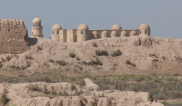
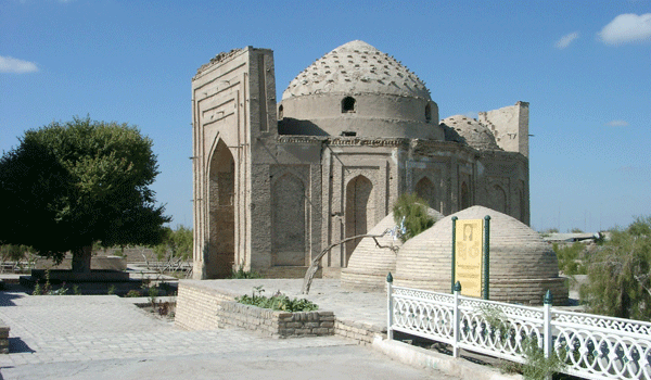
Ancient Merv - the Jewel of the sands. Mary province.
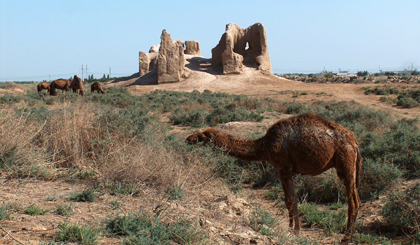
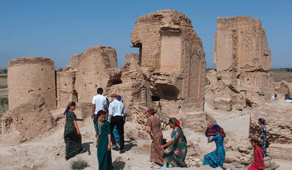
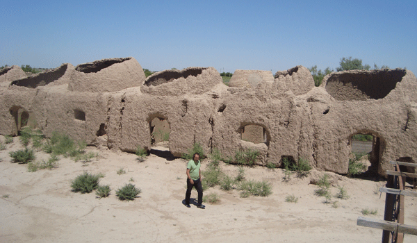
Ancient Merv is the biggest urban center along the Great Silk Route in Central Asia, spanning for more than 2500 years. It consists of a series of separate cities and can be called ‘a wandering city’. The key caravan city Merv enjoyed a very good location on the Great Silk Road . Under the name of Mouru Merv is mentioned in the geography of the Zend Avesta. It occurs as Margu in the cuneiform inscription at the Bekhistun mountain, made by Darius I. Merv under the name of Alexsandria Margiana, was included in the area conquered by Alexander the Great and mentioned by a number of Hellenistic and Roman authors. Alexander is remembered at Merv – the oval northern suburb of the medieval city, known as Iskander Kala is still visible. Visiting Ancient Merv we can explore the process of urbanization in Central Asia. The smallest and earliest city at Merv is Erk Kala ( perhaps the 6th c. B.C.), which is only is 20 hectares. It was enclosed by massive walls and a moat. The only entrance- way had a ramp leading straight to the city.” G. Hermann , who has contributed so much to Turkmenistan archeology, put it as ‘ One of the imposing sites in Merv.’ The city’s wall was continually reinforced until the early Islamic period when both Erk and Gyaur Kala were gradually abandoned. The Seleucids, Alexsander’s successors, founded the second city of Merv ( the 4th c. B.C.), known today as Gyaur Kala, which many experts identify with Antiochia Margiana. The city was built on a Hellenistic grid pattern. It is approximately square and occupies some 360 ha. Roughly in the middle of the site are the ruins of the 7th century mosque and partly ruined sordoba- water cistern. The Seleucids and after the Parthians and Sasanids developed Merv as administrative, cultural, trading and military center. After the battle of Carrhae thousands of Roman soldiers were sent to settle up in Margiana. The Sasanid period was marked by religious tolerance and Sasanid Merv was a meeting point of many religions: Zoroastrianism, Judaism, Christianity, Buddhism, Manichaeism. Under the later Sassanian kings Merv was a seat of a Christian archishopric. In the south east corner of Gyaur Kala one could see a distinguished mound- the remains of the Buddhist Stupa and monastery. This complex was excavated by Masson M. in 1950s and the important finds included the famous ’Merv vase’ and the clay head of a massive statue of Buddha. Two outstanding monuments ,dating back to the Sasanid period are still visible on the territory of Ancient Merv- the Big Kiz Kala and small Kiz Kala ( 6-7 c.c.). However the Turkic name \ in all Turkic languages’ Kiz’ means ‘girl’ \ doesn’t reflect the origin of the constructions. These rectangular clay castles-‘Koshks’ are of interesting architectural design, decorated from outside with corrugations. Different forms of vaults were used in these constructions.
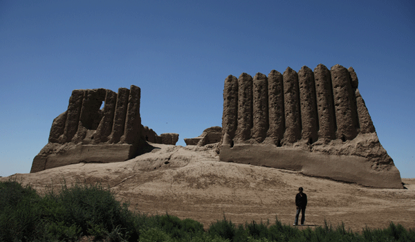
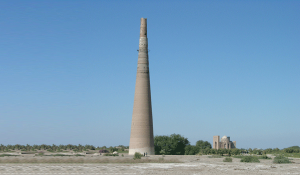
The Moslem Arabs conquered Merv in 651. They moved the city slightly to the west of the original site and made it the capital of Khorosan province. Along with Baghdad, Cairo and Damascus, it was for about eight hundred years one of the important centers of Islam. In those days silk was cultivated in Merv. Merv’s greatest period of glory was under Seljuks ( 11-12 c.c.), who occupied Khorosan and defeated the Ghaznevids near Merv in 1040 , establishing their regional eastern capital here. At this time Merv was called ‘ The Jewel of the sands’, ‘ the Queen of the east’, and Marw al- Shahijan ‘ soul of kings’. The Seljuk capital, consisted of Shakhristan ( medieval citadel) and Rabat( outskirts of the medieval city), considerably exceeded in size Damascus and Jerusalem. Today the Seljuk citadel is called Soltan Kala. It has an oval shape and occupies about 630 hectares. Its layout is still visible in aerial pictures. Among the other cities in Merv, perhaps the most significant is the medieval Seljuk city. The Great Seljuk empire extended from China to Syria and from the Oxus to Arabia. The Seljuks founded a group of dynasties in Persia, Syria and Asia Minor and were responsible for the construction of monumental buildings, notable for their elaborate ornamental brickwork and stucco decorations. They encouraged the arts, all kind of sciences, literature, architecture, employing a considerable variety of domes and vaults. Seljuk Merv was like a magnet to many celebrated scholars, poets and writers, who worked in its legendary libraries and observatory. Among them were Yaqut al – Hanawi, who spent in Mrev about three years collecting material for his geographical dictionary and Omar Khayyam, who compiled his astronomical tables, the so-called Jalal al-Din Calendar working in Merv Observatory. The talent of Omar Khayyam flourished under Malik Shakh, who owed his reputation of the greatest of the Seljuk’great sultans’ mostly to the wise government of his vizier Nizam ul-Mulk. In 1092 Malik Shakh died and the empire experienced a short period of instability. The high point of the Seljuk empire was the rule of Sultan Sanjar ( 1118 - 1157) and his fame eclipsed even that of Malik Shakh. During Sultan Sanjar’s reign Shahriar Ark was constructed- a citadel within the citadel, protected by its own walls and moat. Visiting Shahryar Ark you can see Kepter Khana- an interesting corrugated structure, which is the best-preserved in the citadel. It’s walls still survive to a height of some 4,5 m, however the original height of the walls is hard to determine. The highlight of Ancient Merv is Soltan Sandjar’s mausoleum, which still dominates the landscape. This central-cupola building without a portal is typical of the Khorosan architectural style. The mausoleum was created by Muhammed, the son of Atsyz of Seraks. His name was not found in the historical chronicles, but we could find it in one of the medallions below the cupola of the mausoleum. After the reign of Sultan Sanjar the power of the Seljuks began to wane. In 1221 the Mongols conquered Merv. They destroyed the city, burnt the libraries, demolished the dam and massacred the citizens. One chronicler estimated that 700,000 people were killed here. Merv never fully recovered from this disaster, however the archeological excavations at Merv indicated that Merv was not completely abandoned after the Mongols. In the early fifteen century the descendants of Tamerlane re-built the dam and founded a new urban center just few kilometers to the south of the ruins of the medieval Soltan Kala. The post-medieval city, known today as Abdulakhan Kala, was enclosed by massive walls and a moat with massive ramparts. Being one of the strongest and best fortified cities in the area, Abdulakhan Kala never reached the importance of the previous cities. The remains of the city walls are still impressive, however the walls, the Timurid palace and other constructions in this citadel, as well as four gates were much better preserved in the 19th century. Besides this city the Timurids were responsible for the construction of a series of buildings on the territory of Ancient Merv. In the 18th century Merv came under the rule of amir of Bukhara and in the 19th century amir of Khiva conquered it. However the Tekke Turkomens drove the troops of emir out in 1836 and remained supreme until Russians annexed Merv in 1884. Today, Merv occupies in excess of 1200 ha and forms the biggest archeological site in Central Asia. The importance of the site was recognized in 1999 by UNESKO, which awarded Merv World Heritage status.
Other attractions in Merv Mausoleum of Mukhammed ibn Zaid
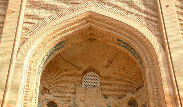
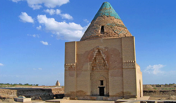
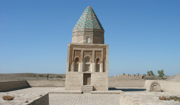
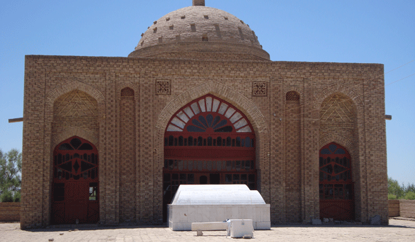
Another Seljuk monument- the mausoleum of Mukhammed ibn Zaid , dated by inscription to 112\13, is located outside the medieval citadel. It is a confusion as to whom the mausoleum is actually devoted. The local legend speak about Mukhammed Said ibn Zeid ibn Ali Zeinal Abedon ibn al- Khusein ibn Ali-Talib, who was a prominent Shia teacher and direct descendant of the Prophet Ali in fifth generation. He died four centuries before and has been buried in Kufa in Arabia. His name and the date of construction are mentioned in the inscription inside the mausoleum. It is one of the important places of pilgrimage in Turkmenistan. Constructing this building the Seljuks implemented a more developed type of squinch. This destination includes a visit of sordoba, also constructed in the Seljuk period. It is a domed construction to store rain water. Access to the water was by a stairway.
Mausoleum of Hodja Yusuf Hamadani
This complex includes a modern mosque and minaret , the mausoleum of Hodja Yusuf Hamadani, Timurid iwan and prayer hall, located not far from the Seldjuk citadel. This complex has been largely reconstructed and turned into important pilgrimage site. Hodja Yusuf Hamadani was a famous Sufi scholar of the 12th century, the founder of Sufi school in Central Asia. He was born in 1048\49 in a small settlement Bezendjird close to Iranian famous city Hamadan The 15th century Tajik poet Djoli mentioned this sepulcher in one of his works.
Ice house ( perhaps 15 c.)
Visible from the road between the medieval and ancient cities of Merv. An extraordinary conical clay construction, built directly on the ground to store tightly packed snow. The original height is hard to determine.
Modern Mary and Mary province
ry is the new town constructed at the beginning of the 19th c. just few kilometers away of the Ancient Merv, having a good strategic location on the way to Persia. The construction of the Trans- Caspian railway gave a further impetus to the development of the town and it became a regional capital of the oasis. The town and the oasis were subjugated to the tsarist Russia without any fights in 1884. In the early 1930s the town and oasis were renamed. Mary province, located in the Murgab valley is the main supplier of fibre cotton, astrakhan fur pelts. It is often reffered to as a land of white and soft gold. Mary is the biggest power supplier in Turkmenistan. The rich gas condensate deposit gave a birth to another settlement near Mary- Shatlyk( joy). Post independence Mary is a small cosy town with clean streets and parks and new buildings.
Mary regional museum
Located in the center of Mary, the museum houses a fine collection of artifacts found at Merv. The museum is open daily, 10.00- 17.00 with a lunch break 13.00-14.00.
Kone Urgench. Dashoguz province
Kone Urgench is located about 100 km northwest of Dashoguz. Today it occupies about 650 ha. The city of Biruni and Avicenna, al Farabi and al Khorezmi was located on the caravan routes which leaded to the Caspian sea and Russia,. The importance of Kune Urgench was recognized by UNESKO, which awarded the site World heritage status. The history of Kune Urgench is closely connected with the history of Khorezm, coming through several periods of flourishing and decays. Khwarezm, Khorezm, Kharizma, Kwarazm and Chorasmia, as the ancient Greeks called it, Hualazimo in Chinese are the names of one important historic region along the Amu-Darya. The prosperity of Kwarizm was built on intensive agriculture, animal husbandry and trade. In 1937 the Soviet Academy of Sciences arranged an archeological expedition to Khorezm and at the head of it was Professor Sergey Pavlovich Tolstov, who identified the city Urva, mentioned in the geography of Zend- Avesta ( Vendidad) with ancient Gurgandj\ Kune Urgench. Today we know dozens of Khorezmian archeological sites- the remains of highly developed urban centers, once set in fertile valleys and connected by caravan roads. Khorezm was dependant to Akhemenids about two centuries. The Khorezmian stone was delivered to Persia for the construction of the Akhemenid palace. Cyrus the Great, whose conquests ranged from Central Asia to the Mediterranean, met a serious resistance in Khorezm. In the 5-4 c.c. B.C. Khorezm was an independent state. The Khorezmian king Pharasmanes made a long trek eastward to greet Alexander the Great in Bactra. It was a temporary set and later like Sogdiana and Trans-Oxiana, Khorezm participated in the struggle against Alexander. Later Khorezm was in the composition of the Kushan empire. Then again became independent and the residence of Khorezmian kings\ shakhs\ moved to the right bank of the Amu-Darya. According to al Biruni Said the citadel of Kath was constructed in 304 B.C. Until the 8 c., when the Arabs brought Islam , Khorezm maintained an authority of independent country and experienced an archaic culture of religions- Zoroasrianism, Christianity, perhaps Judaism. In the 10 c. Khorezm was in the composition of the Samanid state. Under Samanids Khorezm traded with Itel on the Volga and the Khazar kingdom and the variety of goods traded increased significantly. Dried fruit, sweets, broadcloth, carpets, brocade, boats, bows, arrows, falcons, castor oil, fish teeth etc. were available at the bazaars of Gurgandj. The residence of the governor Mamyn was located in Gurgandj, which appeared as the northern capital of Khorezm. However the successors of the local Khorezm dynasty continued to rule in Kath and Khorezm was divided into northern and southern. In 995 Manyn, who received the ancient title of Khorezmsakh, was able to unite Khorezm and Gurgandj became the only capital of a new Khorezmian state. In 1017 Khorezm was conquered by the Gaznevids. Then Oguz Turks came. Alp Arslan suppressed a local rebellion and Khorezm became one of the provinces of the Seljuk state. A new Anushtegin dynasty of Khorezkhakh state was founded in the last years of the 11 c. The founder of the new dynasty was Anush Tegin- an ex slave of the Seljuk emir, who obtained a high position under Malik Shakh, promoted himself and became a governor of Khorezm. Later Khorezm obtained an independence from the Seljuks and became the largest empire of the Middle East with the capital in Gurgandj. It sretched from Iraq in the west till India in the east, from the Aral sea till the Indian ocean in the south. After the Mongol invasion the Empire collapsed and the capital was destroyed. In the 15th c. Khorezm was controlled by Khans of Golden Horde\Altyn Orda\ and the Timurids in turn. Under the Mongols Korezm was the richest and the most cultural province of the Golden Horde and Kune Urgench experienced its second flourishing. Ibn Batuta , a contemporary of Kutlug Timur and Turabek Khanym, visited Kune Urgench in 1333 and found it very beautiful, majestic and of considerable size with large and rich bazaars, wide streets and a lot of impressive buildings . In 1395 the power of Golden Horde ended. After Tamerlane invasion the city was partly rebuilt, but abandoned when the Amu-Darya changed its course in the 16 c..
Landmarks Mausoleum of Turabek Khanym\ constructed 1370
Turabeg Khanym mausoleum is located about 400 m northwest of Kutlug Timur minaret. Behind its tall and deep portal there is a small domed hall( dekhliz)\ with a little khujra\ a cell in a madrasse or caravanserai. Stalactite majolica decorations were employed to decorate the arch of the portal and ‘dekbiz’ ceiling. The building is notable for its remarkable ceiling. The interlocking design of the ceiling of the main hall is still in perfect condition and remarkable in being unrestored. Turabek Khanum was a daughter of the Golden Horde ruler Uzbek Khan, under whose reign The Golden Horde reached its peak.
Kutlug Timur minaret\ finished 1320-30
Located to the south-east of Kyrk Molla. The tallest minaret in Central Asia, is 15 m higher than Bukhara’s Kalyan minaret. Researchers think that the minaret was a part of a huge Friday mosque. The upper part of the minaret leans 1,5 m to the west. Today the minaret is 64m high. A Mongolian governor of Kune Urgench, Kutluk Timur was the most influential and powerful emir of the Golden Horde.
Mausoleum of Soltan Tekesh \early 13th century
The building is notable for its remarkable conical dome, decorated with blue glazed bricks and rather high portal, decorated with stalactite design. The mausoleum has a square base, with walls 11,5 m in length. Soltan Tekesh of the Anushtegin dynasty ruled the Khorezmshakh state from 1172 till 1200.
Kyrk Molla
The remains of the citadel are located just opposite the Tekesh mausoleum. The popular name of the citadel is Kyrk Molla( 40 mullahs). The archeological excavations on the northern slope of the mound opened the fortification wall. The citadel is perhaps the oldest part of Kune Urgench. The earliest ceramics discovered here date back to the 5th c. B.C.
Mausoleum of Il Arslan
Located next to the mausoleum of Khorezmshakh Tekesh the Conqueror. The conical dome of this mausoleum is very Khorezmian. On the main façade we can not see any strong indication of the portal. Three separated niches above the main entrance are decorated with terra-cotta stucco decorations, representing floral designs. Il Arslan ruled the Khorezmshakh sate from 1156 till 1172.
Mamun Minaret
The remains of the minaret are located in the northern part of Dash Kala, which is the ancient site of pre-Mongol Gurgandj.
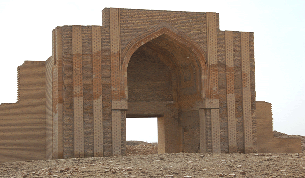
‘The Gate of Caravanserai’
The portal of unknown building is the only monument preserved on the territory of Dash Gala. The building itself does not exist any more. The portal bay is decorated with blue and white majolica, representing floral and geometrical designers. The external side of the arch is decorated with cut brick ornaments.
Nadjmedjin Kubra mausoleum\ constructed 1320-30
The mausoleum consists of entrance hall(dekhliz), two similar rooms on both sides of the hall( 6mx6m) and the shrine ( gurkhana), where we can see the tomb of Nadmendjin Kubra ( 1145-1221)- the great Sufi and the founder of the Kubravid order. We also can enjoy the aquamarine and blue majolica decorations of its portal.
Ashgabat – the capital of Turkmenistan.
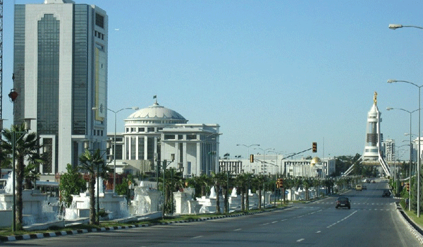
The city was founded in 1881 when the administrative center of the Trans-Caspian province grew up near the ancient fortress of Ashgabat. The construction of Central Asian railway in 1881-1885 gave a powerful incentive to the further development of the city. At the end of the19th century many travelers described Ashgabat as a lovely city of considerable size. The historians suggest that here have been important settlements during the Parthian and Seljuk times. During archeological excavations a number of historical sites have been discovered in and around Ashgabat, which indicate that it has attracted settlers for some thousand of years. However today there are no historical monuments of any great age in the city. The place survived until the 13th century when along with all other main centers in the region, it was razed by the Mongols. The word ‘Ashgabat’ is a composition of two foreign words. Linguists and geographers explain the origin of this word in different ways. The most popular version tells: ‘Eshk’ in Arabic means love or being in love and ‘Abad’ in Persian means a town, a populated spot. Some experts , on the other hand, believe that Ashk was the shortened form of Arshak- the Parthian king. Ashgabat is situated at the foot of the Kopet-Dag mountains, which form a most picturesque background of the city. North of the city there is the Kara Kum desert, which occupies 4\5 of Turkmenistan’s territory. Ashgabat is located 214-240 m above sea level on the 38th parallel along with Cordova( Spain), Athens ( Greece) and San Francisco (USA). Located only few kilometers from the Iranian border, Ashgabat can be regarded as the hub of Turkmenistan land, although at a first glance it would appear to be on the outskirts of Turkmenistan. It is located about 600 km of the most northern, southern, eastern and western Turkmenistan’s points. In 1921 the city was called Poltoratsk. In 1924 Ashgabat became a capital of the Turkmen Soviet social republic. In 1948 the city was completely destroyed by the earthquake measured 9 on the Richter scale, killed 110,000 people. The fraternal republics helped to rebuilt Ashgabat, which was born for a second time after this terrible disaster. Ashgabat of the late 1980s became a typical Soviet city with almost all buildings constructed in a style ’socialist realism in reinforced concrete’. Until this many of its constructions enjoyed a fusion of European and Turkmen architecture. Post-independence Ashgabat is one of the fastest growing and most successful cities in Turkmenistan. It has a good diversity of accommodation and a good choice of restaurants.
Highlights of the city and its suburbs. Arch of Neutrality
One of the landmarks of today Ashgabat is the 75m Arch of Neutrality. The idea of construction of this monument attempted to mark one of the important events in the political life of independent Turkmenistan, when on December 1995 Turkmenistan got the status ‘ Neutral Turkmenistan’. To get a perfect panoramic view of Ashgabat it’s funicular and elevator will take the visitors to a level 60m,where there are three open-air balconies.
National Museum
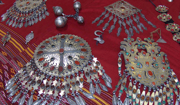
Opened in 1998, the museum 9 halls houses the Turkmenistan’s major collection of artifacts discovered at various excavation sites in Turkmenistan, one of the biggest hand -made carpets in the world, a good collection of Turkmenistan jeweler, called ‘silver rain’ and traditional costumes. The museum is open 10.00-17.00, except Tuesdays and the first Monday of each month.
Turkmen Carpet museum
Opened in 2009, the museum offers an interesting collection of Turkmen carpets. Many of the carpets in this collection are dating back to the 17th century. Here you can see two biggest carpets in the world, one of which is in the Guinness book. The museum is open Monday-Friday 10.00-18.00, with a lunch break 13.00-14.00.
Independence park
One of the biggest parks of post-independence Ashgabat, was first planned in 1993. More than 150 fountains are decorating this park and among them is the highest fountain in the world. At the southern end of this park you can see the Independence monument, which is 118 m high.
Monument to Pushkin
Constructed at the end of the 19th century on the earnings of the Russian intelligent people and survived during the 1948 earthquake.
Monument to Lenin
Constructed in 1927 on the earnings of the working class and peasants of Turkmenistan. It is one of the first monuments to Lenin and the only which is made in the national style and decorated with carpet ornaments in majolica. Survived during the 1948 earthquake.
Monument to Magtymguly
It was constructed in the Soviet period on the place of Bakhai temple, which survived during the 1948 earthquake, but later in the mid-1970s destroyed by the Soviet government. The first classical poet of Turkmens Magtymguly Azadi Oghli Fragi lived in the 18th c. He was a poet, philosopher, thinker, writer and the great majority of his writings have retained their importance today. European readers and researches first became acquainted with Magtymguly’s poems in a book published in England in 1842.
Botanical Gardens
The Botanical Garden is one of the oldest gardens in Central Asia. It was established in 1924\9 and covers about 18ha. It boasts over 1700 species of flowers and ornamental plants. There are more than 500 varieties of roses and 120 of chrysanthemums. You can enjoy seeing Victoria water-lilies in its water pools.
Tolkuchka market
Biggest outdoor market in Central Asia, where you can try your bargaining talents. It is located on the southern outskirts of Ashgabat. Whether you buy anything or not, the lively atmosphere should not be missed. The market is open on Thursdays, Saturdays and on a bigger scale on Sundays. It is the best place in the world to buy Turkmen ‘Bukhara’ carpets. To take them out of Turkmenistan you’ll need to get an export certificate. Sundays are special for the livestock section of this market.
East of Ashgabat Anau\ 12 km east of Ashgabat
This destination includes visit of the ruins of the 15th century mosque, located on the territory of the ancient fortress, which was identified with the Parthian camp of Gatar. The fortress is almost oval and at the southern end of this fortress you can see the remains of the architectural complex, consisted of Djemal- Ad-Din mosque and a tomb in front of it, two large domed buildings. The historical and architectural study of this complex began in the early 20th century and intensified during the 1940s. According to the inscription on its façade, the mosque was constructed by Mukhammed Khudaidot at the time when Khorassan was ruled by Timurid governor Abul- Kasim Baber. In terms of its architectural magnificence, the mosque vied with many famous buildings of the ancient East. Unfortunately during the 1948 earthquake this remarkable monument was completely destroyed. Well glazed bricks were employed for the construction of this complex. The portal was decorated with two dragons each 9m, in black and white majolica. On the northern side of the ruins is a place for holding of the commemorative meal ( sadaka). At a distance from this fortress there are two mounds, which still dominate the landscape. In Turkmen those mounds are called Depe. An American geologist Rafaello Pompelli visited this place at the beginning of the 20th c. and excavated the place. Archeological excavations in Anau testify to the fact that people inhabited this place already in the 4-3 millennium B.C.
Abiverd\ 117 km east of Ashgabat
For many centuries Abiverd occupied a very good position on the Great Silk Route. From Abiverd which in the medieval times became even more prosperous than medieval Nisa, some caravans cut straight across the Turkmen-Khorasan mountains on the way to Nishapur. Others after rest in Rabad of Abiverd continued to Nisa. We know a certain amount about the economy of Abiverd, based on written sources and archeological excavations. The place was famous for its fruit and for its ceramics and metal –working. Abiverd was sacked by the Mongols in 1221.They destroyed the buildings, slaughtering the citizens. Abiverd recovered importance as a small town only centuries later. About this mentioned Khamdellakh Kaznevi. Abiverd enjoyed close connections with Nishapur. And the development of the city has contributed to the further process of urbanization in the area. In the 11th c Abiverd was tussled between the Seljuks and the Gaznevids and was visited by the Seljuk sultan Togrulbek and the Gaznevid sultan Masud.
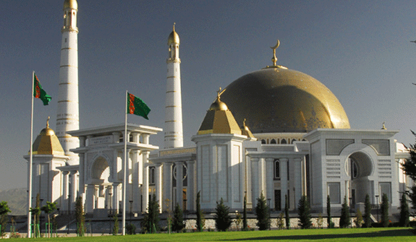
West of Ashgabat Turkmenbashi Ruhy (Spiritual) Mosque. Akhal Province
Turkmenbashi Spiritual Mosque, the largest in Central Asia, is located about 10 km from Ashgabat. The mosque was constructed by the French construction company Bouygues. The same company constructed a huge mosque in Morocco.
Geok Depe fortress. Akhal Province
Geok Depe( ‘Green Hill’) fortress is located about 45 km to the south-west of Ashgabat. This destination includes the modern Saprmurat Khadji mosque, the museum and the ruins of the fortress, where in 1881 a battle between the forces of the Russian tsar and Turkmens- Tekke took place. After the fall of Geok Depe Turkmenistan was subjugated to the Russian empire. The mosque was constructed in 1995 and topped with a blue dome ( Gok Gumbez), rising to a height of 42 m and flanked by four minarets each 63 m tall.
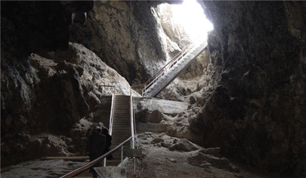
The Bakharden underground lake. Akhal province
The Bakharden underground lake is located in Alhal province, about 107 km south west of Ashgabat . In the world there are some hundreds caverns, which are generated by hot underground water springs. One of these caverns is in our country. The first mention of this cave appeared in the middle of the 19th century in Russian press. The name of this cave is’ Kov Ata’- father of caves. The Bakharden underground lake, which appeared some thousand years ago, is located in this cavern. The water in the lake is connected with the so-called line of thermal water springs of the Kopet Dag range with swimming facilities all a year round. Long ago Turkmens know about existence of this cavern and medicinal characteristics of the water in the lake. Many legends and stories are devoted to the lake and the cave. According to the legends the origin of the lake was ascribed to supernatural forces. One of the legends tells that the cave was discovered by a young Turkmen who fell in love with a young girl. But the girl’s father was against their love. The young Turkmen and the girl fled away from their village- ‘ayl’ in Turkmen. The father and other girl’s relatives persecuted them. The cave opened wide when the young Turkmen and his girl were near the cave quite exhausted and loosing their forces. They got in and at this moment the cave puffed out a black poisoning wind and the persecutors were killed. The young people saw a lake. The warm water in it was pleasant and relaxing , but had an objectionable taste and smell. The smell reminded of rotten eggs. At the end of the 19th century the cave attracted the attention of scientists and they began to study it. High mineralization and temperature ( 33-37 degrees above zero Celsius) testify to the fact that the water in the lake rises from the depth of 600-650 m. Some data about the cave and the lake. The bottom of the lake is 12 m lower the entrance hall. At the end of the cave there is an underground lake. The walls and the vaults of the cave are of lime stone. General length of the cave including the lake is 250 m, its width is 50-57 m, and the height is about 20-35m. The lake is 72 m long. The depth of the lake is between 5-15 m. In the western part of the lake there is a peninsula. The area of the peninsula is 100 square m., which divides the lake into two parts. The water level in the lake depends on season. In winter it is lower than in summer. The water is weekly flowing and transparent, but due to artificial light it is of light green color. It is highly saturated with hydrogen sulphide. The water taken out of the cave in the open air soon loses its smell because hydrogen sulphide evaporates. The quantity of hydrogen sulphide in the water is 11.0 milligram per one litre. Beside it there are 27 chemical elements. The air in the cave is saturated with moister and vapor, especially in summer. Therefore it is not recommended to stay more than 45 minutes especially for those who suffer from cardio-vascular diseases. The effect of the water is very good to the skin and nervous system.
Old Nisa and the Parthian empire.
Old Nisa- the royal residence of the Parthian empire, is located about 18 km south-west of Ashgabad. The Parthian empire was the most enduring of the empires of the ancient Near East. The Parthian empire occupied all of modern Iran, Iraq and Armenia, parts of Turkey, Georgia, Azerbaijan, Turkmenistan, Afghanistan and Tajikistan, and- for brief periods- territories in Pakistan, Syria, Lebanon, Israel and Palestine. A lot of information about the Parthian empire was taken from Chinese historical chronicle, where appeared three great countries: China, Rome and Parthia. Chinese called Parthia ‘a country of beautiful horses, carpets and wine’. The first mention of Parthiena we can find in Iran in the inscription made on the Behistun mountain by Dari Gistaspus. Once Parthiena was one of the satrapies of the Akhemenids and later after Alexander’s death – the Selucids. In the middle of the 3d century B.C. a number of uprisings took place in Central Asia against the Greek- Syrian power and Parthiena was the center of one of such uprisings. At the head of the biggest one was Arsaces, who became a founder of the independent Parthian kingdom and Arsacid dynasty. Later on his death he was defined by Parthians. The end of this empire came in 224 A.D, when the last Parthian king was defeated by one of their vassals, the Persians of the Sassanid dynasty. Not much is known about Parthia. The Parthians left just few written documents. The empire consisted of independent kingdoms, provinces and city-states. Towns like Ctesiphon, Seleucia, Ecbatana, Rhagae, Hecatompylus, Nisa and Susa flourished and toll was one of the sources of royal income. Rome always clashed with Parthia, considering it as the main obstacle on the Great Silk Road. In the I-II centuries B.C. the Parthian kingdom became a powerful state rival to Rome. In 53 B.C. the Roman general Crassus invaded Parthia. Crassus was sixty years old when he became consul and received the provinces of Syria. At that time the territory of the Parthian state stretched up to the Euphrates. Being very ambitious, Crassus wanted to repeat Alexander’s campaign. Caesar and Pompey supported his adventure, probably because they wanted Crassus out of Rome. Crassus brought his army to Syria, crossed the Euphrates and began to occupy the Parthian cities. When his son joined him , a Parthian delegation visited Crassus. Parthians were ready to forgive Crassus because of his age and allow the Roman soldiers to retreat from Parthian lands. Crassus decided to give an answer at Seleucia, at that time one of the main cities of the Parthians. They laughed at this and one of the Parthian ambassadors showed Crassus the palm of his hand, saying’ that hair would grow on it before Crassus ever sees Seleucia’. So it was war and beginning of series of wars to last for almost three centuries. At Carrhae Crassus was beheaded by the Parthians. The Roman army was defeated and Roman prisoners were sent to settle in Margiana.
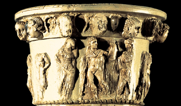
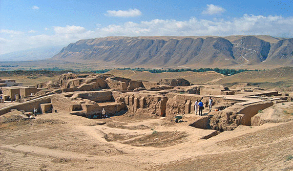
Old Nisa was supposed to be the royal residence of the Parthian kingdom, comprising temples, luxurious palace buildings, the treasury and vast depositories of various kinds. A natural mound was chosen for the construction of Old Nisa. Ancient architects turned it into a strong fortress, pentagonal in plan, with an area of about 18 hectares. The walls of the fortress were perhaps 8-9m thick near the basis and 43 rectangular towers strengthened them additionally. Few artificial water reservoirs were located in the centre of the fortress. The Parthian name of the fortress is known. One of the house-keeping documents, found during the excavations of Old Nisa, has this name- Mithridatkirt ( made by Mthridat). The main buildings of the Old Nisa are grouped into two complexes: the Northern Complex and the Central. The treasure house, wine storage, different workshops and other household buildings were situated in the northern part of Old Nisa. The monumental temples and buildings were grouped in the Central Complex. Perhaps it was the main ritual center of the site. The central place in the Central complex was occupied by the Square hall. This hall was surrounded by few auxiliary chambers. Among them was the Red corridor where you can still observe the traces of red coating. Some researchers suggest that the Square Hall was used for ceremonial receptions. Fired brick was the material for columns and semi-columns. Architectural decorative details were made of terracotta, representing leaves of acanthus, lions, and the most terrible and popular weapon of Parthian horsemen-a bow. We could follow the presence of Hellenistic culture in ornamental decoration of all buildings. The interior of this hall had been repeatedly changed by Parthians. Colorfully painted clay statues decorated the upper wall level. These big statues (more than 2 m) were made by experienced sculptors under Greek canons. The Round Hall ( some 18 m in diameter), still attracting the attention of the visitors, was enclosed into a quadrate of surrounding corridors. Many researchers suggest that deep niches with statues decorated the upper wall level of this hall. Northwest of the Round Hall is the monumental Tower-like building. Two porticoes decorated the entrances to the building. The central part of this construction is occupied by a huge ( about 20x20x7 m ) monolithic square platform. The main chambers were located on the top of it. The architectural style of the Northern complex is quite different. Two structures remaining here are much less striking than those of the Central complex. However some of the most important artifacts were found here during archeological excavations in the 1950s. The largest building here is the so-called Square house ( 60x60m). It consisted of 12 chambers, surrounding a large courtyard. The artifacts found in the chambers of the Square House are of great artistic value- a collection of ivory rhytons, silver figurines, marble items. The building might be the royal treasure house. A huge wine storage was located close to the treasure house, where were supposed to be big clay vessels (khum ). Digging at this site the archeologists found about 2000 written documents on clay ostrakons. Documents are in the Parthian language and Prthians used the Aramaic alphabet. Here is a text of one ostrakon: “ From the estate of Seghabich, from the taxable vineyard in this khum there are 15 measures of vine. Vaiborjan vine supplier from the village of Burkhmekhan brought. Registed under year 179”. Such kind of information helped researchers to learn more about the Parthian economy. Old Nisa was abandoned at the end of the Prthian period. We can identify three periods in the history of archaeological study of Old Nisa. In the 1930s of the 20th century the first archeological excavations took place on the territory of Nissa. This period was marked by documentary verification of the fact that the ancient site of Old Nisa was dated to the Arsacid period. The wide range excavations of Old Nisa were carried out by South Turkmenistan archaeological complex expedition in the 1950-60s of the 20th century. At the head of the excavations was Masson, an archeologist from Leningrad. This period includes a wide range of important discoveries and full archaeological study of the Square House. The third period was also marked by a number of important finds. Since independence archeological excavations at Old Nisa were continued and new discoveries, made during this period are of great importance to understand the Parthian culture and history. The archeological excavations are still going on and far from their completion. The significance of Old Nisa was recognized in 2007 by UNESKO, which awarded the archeological and excavation site World Heritage status.
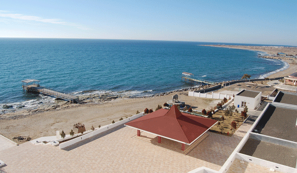
Sea gate of Central Asia. The Caspian Sea. Balkan province
Tukmenistan borders the Caspian’s shores along with Azerbaidjan, Iran, Kazakhstan and Russia. The Caspian sea is completely landlocked, bringing a controversy over whether it is a sea or a lake. Its length is 1,280 km from north to south, and its breadth about 443 km. Its area reaches 393,680 sq. km, of which about 2,331 sq. km belong to its islands. The Caspian sea fills the deepest part of a vast depression, sometimes known as the Aralo-Caspian depression. The coastal line running along Turkmenistan’s territory is approximately 650 km. The Caspian coastline is home to an amazingly diverse array of marine and wildlife. Among 120 different species of fish of the Caspian sea , seven are different sturgeon species, some of which are found nowhere else in the world. The Caspian seal and the magnificent white tailed sea eagle both call the Caspian sea home. Hundreds of thousands of birds stay here for five-month wintering. Pink flamingos, three species of swans, geese, ducks, coots are among them.
The biggest port in Turkmenistan
Turkmenbashi, former Krasnovodsk, is the oldest city in Balkan province. It has a remarkable geographical location with a range of low grounds and cliffs, which encircle the city. Krasnovodsk began its existence as a gateway to Central Asia and also as dockers’ town. Turkmenbasi is growing and today it is one of the biggest industrial and tourist centers of Turkmenistan. There is an interesting museum in Turkmenbashi where you can get acuainted with mineral resources of Turkmenistan , fauna of the Caspian sea and Turkmenistan marine history.
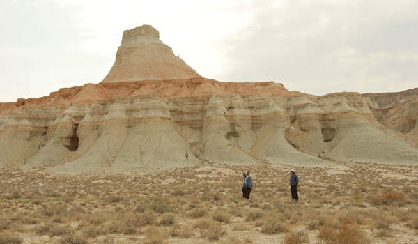
Canyon country. Yangykala and Yangysuw
Located about 250 km of Turkmenbashi. A trip to this country of canyons is an authentic adventure. This destination combines unique sceneries of white, green, pink and reddish rocks, breathtaking views and diversity of terrains- hilly, mountainous and smooth.
Located about 130 km from Jebel, The mausoleum of Gozli Ata is the most remote place of shrine pilgrimage in Turkmenistan. Hasan Ata Asyky Gozli Ata ( 1110-1221) was a legendary Sufi teacher. The mausoleum has a remarkable location with a range of white, pink, greenish and reddish rocks, which encircle the place. The graveyard at the southern edge of the place is interesting for its nicely carved stone tombs. A world of adventure, stunning nature, history and culture awaits you in this province.
Its area is nearly 350.000 sq.km., which is about 79 per cent of Turkmenistan’s territory. The desert is bounded on the north-west by the Ust urt plateau, on the north- east by the Amu-Darya, on the south by the oasis and on the west it nearly reaches the Caspian sea. The Kara Kum desert is divided into three parts: Low( Central), Zungusskie( Northern) and South –eastern. The desert is rich not only in oil and gas but other mineral resources as well. A wide range of grey mounds dominate the landscape along the boundaries of Zunguz Kara Kums. Inside those mounds there are deposits of sulphur. From outside they are covered with flint crust. The landscape of the Kara Kums is very interesting. Only part of its territory is covered with sand. In the east there are ‘barkhans’- mounds of loose sand,\\\\15 to 35 m high. There are flat areas of broad expanses (takyrs) of clay soil. In contrast to sands ‘ takyrs’ can keep moisture created by rains on the level of 25-30 m deep. However in May moister reserves in takyrs end. So ‘takyrs’ are called lifeless. Nothing is growing on it. The sand can keep winter moister and spring rains on the level of one metre deep. Desert acacia and poplar, white and black saksaul are growing on such areas. There are also ‘shors’, similar to above but encrusted with salt and relieved by solanaceae along their borders. A typical feature of the Kara Kum is a number of “ old beds”, which may have been either channels of tributaries of the Oxus and other rivers, or depressions which contained salt lakes. Shifting dunes offer a continually changing desert landscape. Spring in the Kara Kum desert is fantastic and it doesn’t look like a desert at this time of a year. For more than two weeks it is covered with green, pink, yellow and red ‘carpets’ of different flowers - bright red poppies, gipecuum, sandy sedge, the bushes of astragalus and kandym. This desert remained in many ancient chronicles, Two thousand years ago Herodotus wrote about it. But desert life was quite different at those times. But also today the desert generously providing people with karakul pelts, wool, meat and camel’s milk.
Active adventures in the Kara Kum desert
This tour combines visit of a pure Turkmen settlement in the Kara Kum desert, visit of Kaplankyr nature reserve, relaxing at yurt with the excitement of seeing water crater by day and the flaming crater by night, taking a bath in Issi Suw ( hot water spring). We’ll drive to Erbent, surrounded by sand dunes, to milk a camel, see a hunting dog tazy, taste camel’s milk, participate in felt making and enjoy a Turkmen warm hospitality. Anyone who spent time with a Turkmen family will confirm that the warm nature of the Turkmen people is not something specially created for tourist brochures, it exists for real. Genuine friendless is as natural to the Turkmen people as to make traditional chourek\bred.
Ahun Baba Medrese (XIXc.)
Talkhatan Baba mausoleum (XIc.)
Soltanbent dam (XIXc.)
The Repetek Nature Reserve. Lebab province
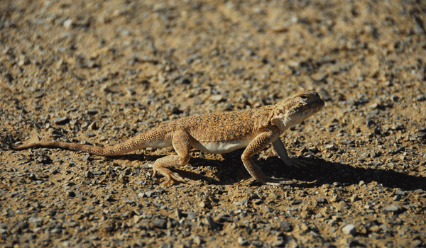
In Turkmenistan there are 8 Nature Reserves and three of them are located in Lebap province- the Repetek, Amudarinski and Kugitang Nature Reserves. The Repetek Nasture Reserve was founded in 1927 and occupies a territory of more than 35 000 hectares to study unique desert fauna and flora. It is located in the central part of the eastern Kara Kums and about 70 km southwest of Turkmenabad. The unique natural ecosystem of Repetek attracted the attention of many scientists and a number of scientific conferences and seminars were held here. The importance of Repetek was recognized by UNESCO and in 1979 Repetek obtained the status of an International Biosphere Reserve. Repetek is a place where we can observe practically all forms of the Kara Kum’s sandy landscape, which are dune-like, ridge-like, hilly and other possible variations, as well as striking the attention ‘Repetek Sahara’ and groves of white and black saxaul ( haloxylon )- a forest without a shade. We call saxaul a tree without leaves. It has leaves, but they are so thin. It helps the saxaul tree to withstand the extremeness of temperature and harsh climate. Repetek is blessed with more than 240 sunny days a year and the temperature of the sandy surface is often 80 degrees C. Turkmens consider saxaul tree the best to make a fire in a tamdyr, where they bake the traditional round bread ‘chorek’. Another interesting trees in the Repetek are silver acacia, weeping willow. The Repetek Nature Reserve is home to an amazingly diverse array of fauna. There are 300 different species of beetles, 160 species of butterflies, spiders. The venom of ‘karakurt’ spider is 8-9 times stronger than that of cobra and its bite is much more dangerous than scorpion, phalanx and tarantula. The ornitho-fauna consists of more than 160 species of birds and among them are saxaul jay, a golden eagle, owl, falcon, buzzard, kestrel etc. Only in Repetek you can observe four different species of sparrow. Repetek is a kingdom of reptiles. There are 30 species of lizards, 9 species of snakes and tortoises. Among mammals are foxes, gazelles, steppe and dune cats, porcupines, jerboas, ground squirrel, jackals.
Other highlights in Repetek include visit of the Repetek museum with an interesting collection of stuffed animals, pickled reptiles and a small collection of pottery, reminding that Repetek was once a staging point on the Great Silk Road across the desert to Ancient Merv. On hand to interpret the sights will be experts on ornithology, flora and fauna of the arid zones. |
||||||

|
Travel info | Turkmenistan | Awaza | Tours | Highlights | Visa support | Hotels | Contact us
|